 RailTrailWxRailTrailWx

E-bikingBikingWalkingRunningBirdingFishingand more
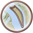
Hains Point Loop circles East Potomac Park, a flat, man-made island between the Washington Channel and the Potomac River in Southwest Washington. It starts by the Jefferson Memorial, where it meets the National Mall Loop. From there it follows Ohio Drive SW about 4 miles around the island and back. The path is one lane of Ohio Drive set aside for people on foot and on bikes. It runs two ways and sits behind a row of parked cars. Japanese cherry trees line much of the drive, and the golf links fill the middle of the island. At the southern tip, Hains Point looks out where the Potomac and Anacostia rivers meet.
Hains Point Loop
Your comfort. Prognosticated.
-Cory

In a typical year the Hains Point Loop has about 119 to 164 days of excellent weather for popular activities such as hiking, dog walking, birding, e-biking, running, biking, and walking, with April, October, and November the best months.
Hourly comfort scores for the next 15 days of weather, tuned to your activity and your own thresholds.
Plan your visit to this trail. Get the best windows for a comfortable outing.
Enjoy the Hains Point Loop!

In half of past years, color along the Hains Point Loop peaks November 2 to 13, typically around November 8. The trail has 12% deciduous coverage, with the majority being yellow-poplar, sweetgum, white oak, and red maple.
Every foot of this loop rests on mud the Army Corps of Engineers pulled from the bottom of the Potomac River. For most of the 1800s, the Potomac Flats were mud and marsh at the city's edge. In 1870, the Corps began dredging the river to deepen the ship channel. Five years later, it proposed filling the flats with the dredged spoil. A flood in 1881 added urgency. By 1882, Major Peter Conover Hains had finished most of the dredging and reclamation. Hains also designed the Tidal Basin and set how river water flows into it. On March 3, 1897, Congress set the new ground aside to be held forever as a park for the recreation and pleasure of the people. Dredging went on into the 1910s. In 1915 and 1916, crews planted Japanese cherry trees along the roadway. The golf course opened its first nine holes in 1920, and a teahouse, a tourist campground, and stables followed. Until 1949, The island's southern tip carries Hains's name. In July 2023, the National Park Service began turning one lane of Ohio Drive into a two-way path for people on foot and on bikes, protected behind parked cars.